How to Read a Topo Map
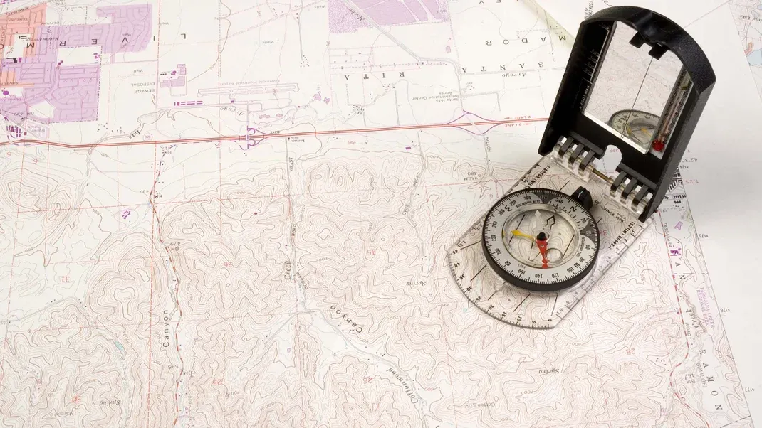
A topographic map, or topo map, uses contour lines to represent the shape and elevation of the land. To read a topo map, start by understanding the contour lines and what they represent. Each line represents a specific elevation, and the closer the lines are together, the steeper the terrain. The map also includes symbols and colors to indicate different features such as roads, water bodies, and vegetation. The key or legend on the map will explain these symbols. To navigate using a topo map, pay attention to the contour lines and use them to visualize the terrain and plan your route.

A topographic map, often referred to as a topo map, is a detailed and accurate representation of the natural and man-made features of a landscape. It is a valuable tool for hikers, backpackers, and outdoor enthusiasts as it provides important information about the terrain, including elevation, vegetation, water sources, and more. Learning how to read a topo map is essential for anyone who spends time in the outdoors, as it can help you navigate and plan your trips more effectively.
The first step in reading a topo map is understanding the basic elements. Topo maps use contour lines to represent the shape and elevation of the land. These lines connect points of equal elevation, allowing you to visualize the three-dimensional landscape on a two-dimensional map. Each contour line represents a specific elevation, and the spacing between lines indicates the steepness of the terrain. Closer lines indicate steep slopes, while wider spacing indicates flatter areas.
In addition to contour lines, topo maps also include a variety of symbols and colors to represent different features. These may include rivers, lakes, roads, trails, buildings, and more. Understanding these symbols and colors is crucial for interpreting the map and planning your route.
One of the most important features of a topo map is the scale. The scale provides a ratio that allows you to determine the actual distance represented on the map. For example, a map with a scale of 1:24,000 means that one unit of measurement on the map represents 24,000 of the same units in real life. This allows you to accurately calculate distances and plan your route accordingly.
Another important aspect of a topo map is the legend, which provides a key to understanding the symbols and colors used on the map. The legend will explain what each symbol represents, making it easier to interpret the map and identify important features.
Once you understand the basic elements of a topo map, you can start using it to navigate and plan your trips. One of the most common uses of a topo map is for determining elevation gain and loss. By following the contour lines, you can see the changes in elevation along your route and estimate the total elevation gain and loss. This is essential for planning hikes and backpacking trips, as it allows you to gauge the difficulty of the terrain and plan your pace accordingly.
Topo maps are also useful for identifying natural features such as water sources, cliffs, and ridges. By studying the contour lines and symbols, you can locate rivers, lakes, and other water sources, as well as potential hazards such as steep cliffs or rocky terrain. This information is crucial for planning a safe and enjoyable trip in the outdoors.
In addition to navigation, a topo map can also provide valuable information about the surrounding vegetation and land cover. By studying the colors and symbols on the map, you can identify different types of vegetation, such as forests, grasslands, and marshes. This can help you plan your route and anticipate the type of terrain you will encounter.
When using a topo map for navigation, it's important to keep in mind that the map represents a snapshot in time and may not always reflect the current conditions on the ground. For example, trails and roads may have changed or become overgrown, and natural features such as rivers and lakes may have shifted. It's important to use the map in conjunction with other tools, such as a compass and GPS, and to be prepared to make adjustments based on the actual conditions you encounter.
In conclusion, learning how to read a topo map is an essential skill for anyone who spends time in the outdoors. By understanding the basic elements of a topo map, such as contour lines, symbols, scale, and legend, you can use the map to navigate, plan your trips, and gain a better understanding of the landscape. With practice and experience, you can become proficient in interpreting and using a topo map to enhance your outdoor adventures.


